Blue Mountains Suburbs & Region, Blue Mountains Map & Postcodes
Blue Mountains Suburbs & Region, Blue Mountains Map & Postcodes in Blue Mountains, Sydney Outer West and Blue Mountains, NSW, AU
Blue Mountains Region
Region Name
Blue Mountains (NSW, AU)Blue Mountains Area
942.41 square kilometers (942.41 ㎢)Postal Codes
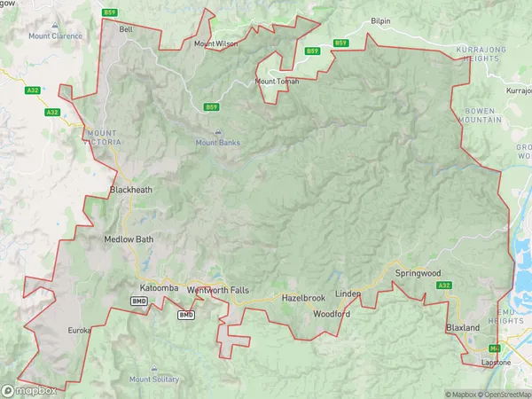
2758, 2773, 2774, from 2776 to 2780, from 2782 to 2786, and 2790 (In total, there are 14 postcodes in Blue Mountains.)Blue Mountains Suburb Area Map (Polygon)
Blue Mountains Introduction
The Blue Mountains are a mountain range located west of Sydney, in New South Wales, Australia. They are known for their stunning scenery, including waterfalls, forests, and panoramic views. The Blue Mountains are a popular destination for hiking, camping, and wildlife watching. The region is home to a variety of plant and animal species, including the rare Blue Mountains kangaroo and the Wollemi pine. The Blue Mountains were formed over millions of years by volcanic activity and erosion. The highest peak in the range is Mount Werong, which stands at 1,215 meters (3,986 feet) above sea level. The area is also home to several historic sites, including the Katoomba Scenic Railway and the Jenolan Caves.Australia State
City or Big Region
District or Regional Area
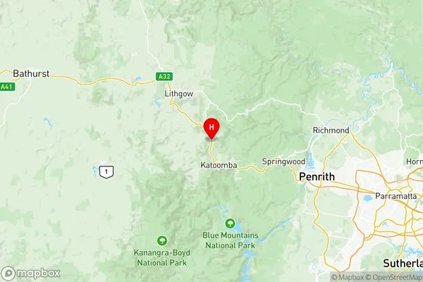
Blue Mountains Region Map
Blue Mountains Postcodes / Zip Codes
Blue Mountains Suburbs
Kurrajong Heights Ebenezer
Blackheath Megalong Valley
Blaxland Warrimoo Lapstone
Lawson Hazelbrook Linden
Blue Mountains full address
Blue Mountains, Sydney Outer West and Blue Mountains, New South Wales, NSW, Australia, SaCode: 12401Country
Blue Mountains, Sydney Outer West and Blue Mountains, New South Wales, NSW, Australia, SaCode: 12401
Blue Mountains Suburbs & Region, Blue Mountains Map & Postcodes has 10 areas or regions above, and there are 88 Blue Mountains suburbs below. The sa3code for the Blue Mountains region is 12401. Its latitude and longitude coordinates are -33.6356,150.284.
Blue Mountains Suburbs & Localities
1. Berambing
2. Kurrajong
3. Kurrajong Heights
4. Mount Tomah
5. Lapstone
6. Blaxland East
7. Hawkesbury Heights
8. Winmalee
9. Hazelbrook
10. Katoomba Dc
11. Lawson
12. Dargan
13. Clarence
14. Hartley Vale
15. Hassans Walls
16. Lithgow
17. Mount Lambie
18. Newnes
19. Sheedys Gully
20. South Bowenfels
21. Vale Of Clwydd
22. Wolgan Valley
23. Wollangambe
24. Mountain Lagoon
25. Glenbrook
26. Mount Riverview
27. Springwood
28. Valley Heights
29. Woodford
30. Katoomba
31. Megalong
32. Bowenfels
33. Clarence
34. Cullen Bullen
35. Good Forest
36. Lidsdale
37. Little Hartley
38. Lowther
39. South Littleton
40. Springvale
41. Bilpin
42. Blaxlands Ridge
43. Kurrajong Hills
44. Blaxland
45. Warrimoo
46. Sun Valley
47. Leura
48. Yosemite
49. Wentworth Falls
50. Bullaburra
51. Megalong Valley
52. Shipley
53. Mount Irvine
54. Mount Wilson
55. Ben Bullen
56. Blackmans Flat
57. Cobar Park
58. Ganbenang
59. Hampton
60. Hartley
61. Hermitage Flat
62. Jenolan
63. Marrangaroo
64. Mckellars Park
65. Oaky Park
66. Pottery Estate
67. Sodwalls
68. State Mine Gully
69. East Kurrajong
70. The Devils Wilderness
71. Wheeny Creek
72. Faulconbridge
73. Yellow Rock
74. Linden
75. Medlow Bath
76. Blackheath
78. Mount Victoria
79. Corney Town
80. Doctors Gap
81. Jenolan Caves
82. Kanimbla
83. Lithgow Dc
84. Littleton
85. Morts Estate
86. Newnes Plateau
87. Oakey Park
88. Rydal