Devonport Suburbs & Region, Devonport Map & Postcodes
Devonport Suburbs & Region, Devonport Map & Postcodes in Devonport, West and North West, TAS, AU
Devonport Region
Region Name
Devonport (TAS, AU)Devonport Area
1894 square kilometers (1,894 ㎢)Postal Codes
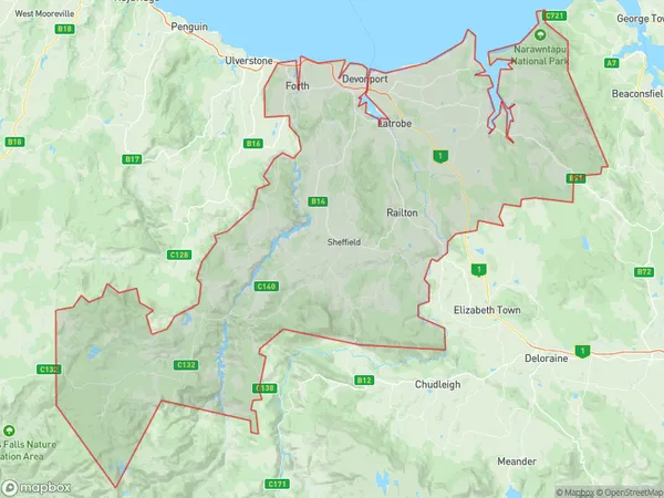
7270, 7275, 7304, 7305, 7307, 7310, and 7315 (In total, there are 7 postcodes in Devonport.)Devonport Suburb Area Map (Polygon)
Devonport Introduction
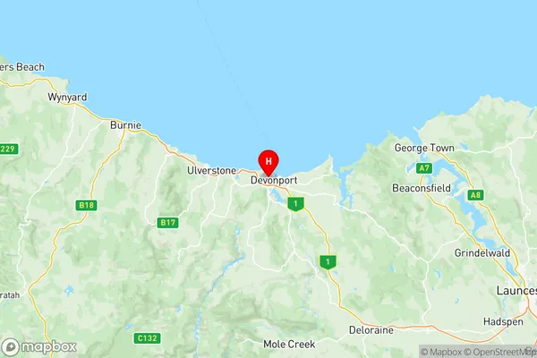
Devonport is a city in Tasmania, Australia. It is located in the Devonport Region, which is in the north-west of the state. The city is situated on the Mersey River, which flows into Bass Strait. Devonport is a major industrial and port city, with a population of around 20,000 people. The city is home to a number of major businesses, including the Devonport Dockyard, which is one of the largest shipyards in the Southern Hemisphere. The city is also a popular tourist destination, with a number of attractions and landmarks, including the Devonport Regional Gallery, the Devonport Central Shopping Centre, and the Tasmanian Museum and Art Gallery.Australia State
City or Big Region
District or Regional Area
Devonport Region Map
Devonport Postcodes / Zip Codes
Devonport Suburbs
Beauty Point Beaconsfield
Central Highlands
West Ulverstone
East Devonport
Quoiba Spreyton
Turners Beach Forth
Devonport full address
Devonport, West and North West, Tasmania, TAS, Australia, SaCode: 60402Country
Devonport, West and North West, Tasmania, TAS, Australia, SaCode: 60402
Devonport Suburbs & Region, Devonport Map & Postcodes has 13 areas or regions above, and there are 110 Devonport suburbs below. The sa3code for the Devonport region is 60402. Its latitude and longitude coordinates are -41.1771,146.345.
Devonport Suburbs & Localities
1. Clarence Point
2. Frankford
3. Loira
4. Swan Point
5. Breona
6. Chudleigh
7. Kimberley
8. Meander
9. Mersey Forest
10. Needles
11. Parkham
12. Beaconsfield
13. Flowery Gully
14. Rowella
15. Deviot
16. Exeter
17. Glengarry
18. Lanena
19. Notley Hills
20. Winkleigh
21. Caveside
22. Dairy Plains
23. Dunorlan
24. Golden Valley
25. Jackeys Marsh
26. Liena
27. Mayberry
28. Reedy Marsh
29. Reynolds Neck
30. Merseylea
31. Hawley Beach
32. Shearwater
33. Squeaking Point
34. Devonport
35. Don
36. Erriba
37. Kindred
38. Lillico
39. Paloona
40. Stony Rise
41. Gunns Plains
42. Turners Beach
43. Ulverstone
44. Latrobe
45. Sassafras
46. Eugenana
47. Lower Wilmot
48. Tarleton
49. Abbotsham
50. Leith
51. Loongana
52. Nietta
53. North Motton
54. South Preston
55. Spalford
56. Upper Castra
57. Greens Beach
58. Sidmouth
59. Brandum
60. Deloraine
61. Badger Head
62. Beauty Point
63. Ilfraville
64. Kayena
65. Kelso
66. York Town
67. Blackwall
68. Holwell
69. Robigana
70. Central Plateau
71. Elizabeth Town
72. Moltema
73. Montana
74. Quamby Brook
75. Weegena
76. Bakers Beach
77. Moriarty
78. Port Sorell
79. Thirlstane
80. Wesley Vale
81. Aberdeen
82. Ambleside
83. Forth
84. Forthside
85. Miandetta
86. Quoiba
87. South Spreyton
88. Castra
89. South Nietta
90. Sprent
91. Doctors Point
92. Mole Creek
93. Red Hills
94. Walls Of Jerusalem
95. Weetah
96. Western Creek
97. Railton
98. Sunnyside
99. Harford
100. Northdown
101. East Devonport
102. Melrose
103. Moina
104. Spreyton
105. Tugrah
106. West Devonport
107. Wilmot
108. Gawler
109. Preston
110. West Ulverstone