Perth South East Suburbs & Region, Perth South East Map & Postcodes
Perth South East Suburbs & Region, Perth South East Map & Postcodes in Perth South East, WA, AU
Perth South East Region
Region Name
Perth South East (WA, AU)Perth South East Area
2024 square kilometers (2,024 ㎢)Postal Codes
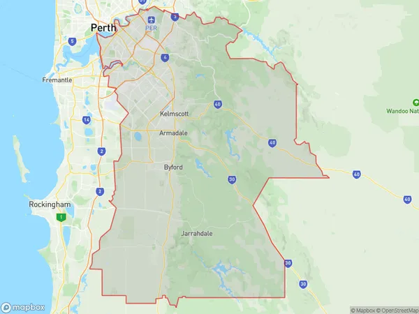
from 6055 to 6058, 6076, from 6100 to 6110, 6112, from 6121 to 6126, 6147, 6148, 6151, 6152, 6925, 6926, 6935, 6951, 6952, from 6979 to 6990, and 6992 (In total, there are 45 postcodes in Perth South East.)Perth South East Suburb Area Map (Polygon)
Perth South East Introduction
Perth South East is a suburb of Perth, the capital city of Western Australia, and is located in the City of Cockburn. It is situated approximately 16 kilometers southeast of Perth's central business district (CBD) and is part of the City of Cockburn's urban growth area. The suburb is named after the South East River, which flows through it. It is a primarily residential area with a mix of single-family homes, apartments, and townhouses. The suburb has a variety of amenities, including a shopping center, a medical center, a library, and several parks and recreational facilities. Perth South East is well-connected to the rest of Perth via public transportation, with several bus routes and the Cockburn Central railway station located within the suburb. The suburb is also home to several major roadways, including the Kwinana Freeway and the Graham Farmer Freeway. In terms of demographics, Perth South East is a diverse suburb with a mix of different ethnicities and cultures. The population is estimated to be around 30,000 people, with a majority of residents being of Australian descent. There is also a significant population of immigrants from various countries, including India, China, and Vietnam. Overall, Perth South East is a popular suburb with a mix of residential and commercial properties, excellent amenities, and a convenient location. It is a great place to live and work, with plenty of opportunities for entertainment andAustralia State
City or Big Region
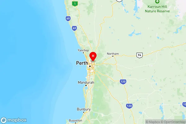
Perth South East Region Map
Perth South East Postcodes / Zip Codes
Perth South East Suburbs
Belmont Victoria Park
Serpentine Jarrahdale
Perth South East full address
Perth South East, Western Australia, WA, Australia, SaCode: 506Country
Perth South East, Western Australia, WA, Australia, SaCode: 506
Perth South East Suburbs & Region, Perth South East Map & Postcodes has 7 areas or regions above, and there are 133 Perth South East suburbs below. The sa4code for the Perth South East region is 506. Its latitude and longitude coordinates are -31.8271,115.969.
Perth South East Suburbs & Localities
2. Reservoir
3. Dayton
4. Guildford
6. Armadale
7. Belmont
8. Carlisle
9. East Victoria Park
10. Kewdale
11. Rivervale
12. Cloverdale
13. Lathlain
14. Victoria Park
15. St James
16. Wilson
17. Bentley
18. Bentley Dc
19. Cannington
20. Lynwood
21. Ferndale
22. Welshpool
23. Welshpool Dc
24. Gosnells
25. Maddington
26. Thornlie
27. Forrestfield
28. High Wycombe
29. Kalamunda
30. Walliston Dc
31. Byford
32. Oakford
33. Whitby
34. Mardella
35. Keysbrook
36. Jarrahdale
37. Como
38. Kensington
39. South Perth