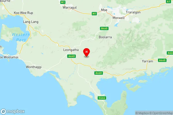
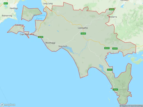
Gippsland South West Suburbs & Region, Gippsland South West Map & Postcodes
Gippsland South West Suburbs & Region, Gippsland South West Map & Postcodes in Gippsland South West, Latrobe Gippsland, VIC, AU
Gippsland South West Region
Region Name
Gippsland South West (VIC, AU)Gippsland South West Area
4382 square kilometers (4,382 ㎢)Postal Codes
3835, from 3921 to 3923, 3925, 3945, 3946, 3950, 3951, 3953, 3954, from 3956 to 3960, 3964, 3965, 3979, 3988, from 3990 to 3992, 3995, and 3996 (In total, there are 25 postcodes in Gippsland South West.)Gippsland South West Introduction
Gippsland South West is a locality in the local government area of the Shire of Buloke, Victoria, Australia. It is located 217 kilometers (135 mi) east of Melbourne, the state capital. The post office opened as Taralga on 1 August 1891 and was closed on 21 November 1922. The name was changed to Gippsland South West on 1 July 1927. The town is in the Buloke irrigation area and is a service center for the surrounding farming community. It has a primary school and a post office. The nearest railway station is in Mirboo North. The Gippsland South West Football Club is an Australian Rules Football Club that competes in the Buloke Football League. The club was founded in 1927 and has won five premierships.Australia State
City or Big Region
District or Regional Area
Gippsland South West Region Map

Gippsland South West Postcodes / Zip Codes
Gippsland South West Suburbs
Wilsons Promontory
Gippsland South West full address
Gippsland South West, Latrobe Gippsland, Victoria, VIC, Australia, SaCode: 20503Country
Gippsland South West, Latrobe Gippsland, Victoria, VIC, Australia, SaCode: 20503
Gippsland South West Suburbs & Region, Gippsland South West Map & Postcodes has 5 areas or regions above, and there are 119 Gippsland South West suburbs below. The sa3code for the Gippsland South West region is 20503. Its latitude and longitude coordinates are -38.5339,146.094.
Gippsland South West Suburbs & Localities
1. French Island
2. Sunderland Bay
3. Newhaven
4. Summerlands
5. Ventnor
6. Woodleigh
7. Kardella South
8. Korumburra
9. Korumburra South
10. Strzelecki
11. Kongwak
12. Moyarra
13. Berrys Creek
14. Koorooman
15. Leongatha South
16. Trida
17. Middle Tarwin
18. Stony Creek
19. Buffalo Creek
20. Wild Dog Valley
21. Wooreen
22. Koonwarra
23. Walkerville North
24. Grassy Spur
25. Hoddle
26. Boolarong
27. Foster North
28. Mount Best
29. Yanakie
30. Glen Alvie
31. Korrine
32. Poowong East
33. West Creek
34. Anderson
35. North Wonthaggi
36. Powlett River
37. St Clair
38. Inverloch
39. Pound Creek
40. Waratah Bay
41. Wilsons Promontory
42. Wonga
43. Woorarra West
44. Almurta
45. Kernot
46. Glen Forbes
47. Dalyston
48. Woolamai
49. Thorpdale
50. Silverleaves
51. Sunset Strip
52. Wimbledon Heights
53. Cape Woolamai
54. Churchill Island
55. Krowera
56. Loch
57. Arawata
58. Kardella
59. Boorool
60. Leongatha
61. Mount Eccles
62. Ruby
63. Meeniyan
64. Tarwin Lower
65. Venus Bay
66. Buffalo
67. Fish Creek
68. Sandy Point
69. Bennison
70. Foster
71. Shallow Inlet
72. Tidal River
73. Turtons Creek
74. Mountain View
75. Poowong
76. Poowong North
77. Bass
78. Harmers Haven
79. Hicksborough
80. South Dudley
81. Wonthaggi
82. Elizabeth Island
83. Tankerton
84. Cowes
85. Smiths Beach
86. Surf Beach
87. Rhyll
88. San Remo
89. Bellview
90. Jeetho
91. Bena
92. Whitelaw
93. Fairbank
94. Jumbunna
95. Outtrim
96. Ranceby
97. Hallston
98. Leongatha North
99. Mardan
100. Mount Eccles South
101. Nerrena
102. Dumbalk
103. Dumbalk North
104. Mirboo South
105. Tarwin
106. Walkerville
107. Walkerville South
108. Waratah North
109. Gunyah
110. Rumbug
111. Port Franklin
112. Port Welshpool
113. Blackwood Forest
114. Ryanston
115. Archies Creek
116. Cape Paterson
117. Kilcunda
118. Lance Creek
119. Wattle Bank
