Latrobe Gippsland Suburbs & Region, Latrobe Gippsland Map & Postcodes
Latrobe Gippsland Suburbs & Region, Latrobe Gippsland Map & Postcodes in Latrobe Gippsland, VIC, AU
Latrobe Gippsland Region
Region Name
Latrobe Gippsland (VIC, AU)Latrobe Gippsland Area
41553 square kilometers (41,553 ㎢)Postal Codes
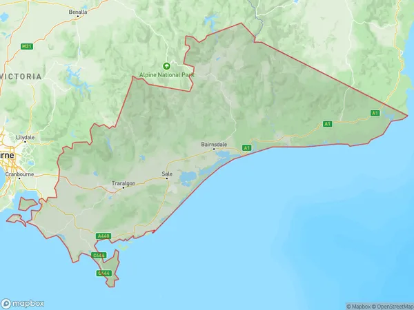
2633, 3699, 3701, 3707, 3723, 3818, from 3820 to 3825, 3831, 3832, 3835, 3840, 3842, 3844, 3847, from 3850 to 3854, from 3856 to 3860, 3862, 3864, 3865, from 3869 to 3871, from 3873 to 3875, 3878, 3880, 3882, from 3885 to 3893, 3895, 3896, 3898, 3900, from 3902 to 3904, 3909, from 3921 to 3923, 3925, 3945, 3946, 3950, 3951, 3953, 3954, from 3956 to 3960, 3962, from 3964 to 3967, 3971, 3979, 3988, from 3990 to 3992, 3995, and 3996 (In total, there are 86 postcodes in Latrobe Gippsland.)Latrobe Gippsland Suburb Area Map (Polygon)
Latrobe Gippsland Introduction
Latrobe Gippsland is a locality in the Gippsland region of Victoria, Australia. It is located in the Shire of Buloke, 146 kilometers east of Melbourne's central business district. Latrobe Gippsland has a population of around 10,000 people and is known for its agriculture, particularly dairy farming and fruit growing. The town is home to the Latrobe Valley Power Station, which is a major source of electricity for the region. The town also has a number of historic buildings, including the Latrobe Courthouse and the Latrobe City Hall. Latrobe Gippsland is surrounded by beautiful natural scenery, including the Great Dividing Range and the Mount Wellington National Park. The town is also home to a number of festivals and events, including the Latrobe Valley Food and Wine Festival and the Latrobe Valley Country Music Festival.Australia State
City or Big Region
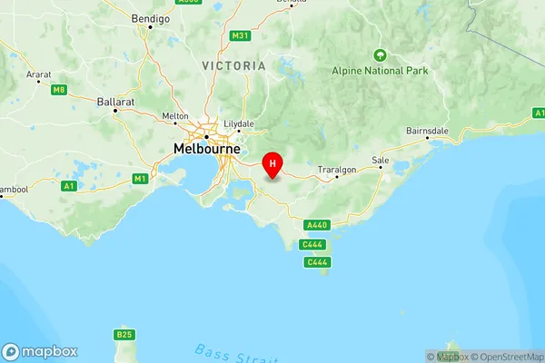
Latrobe Gippsland Region Map
Latrobe Gippsland Postcodes / Zip Codes
Latrobe Gippsland Suburbs
Gippsland East
Gippsland South West
Latrobe Valley
Wellington
Latrobe Gippsland full address
Latrobe Gippsland, Victoria, VIC, Australia, SaCode: 205Country
Latrobe Gippsland, Victoria, VIC, Australia, SaCode: 205
Latrobe Gippsland Suburbs & Region, Latrobe Gippsland Map & Postcodes has 5 areas or regions above, and there are 606 Latrobe Gippsland suburbs below. The sa4code for the Latrobe Gippsland region is 205. Its latitude and longitude coordinates are -38.2387,145.759.
Latrobe Gippsland Suburbs & Localities
1. Delegate
2. Wallagaraugh
3. Martins Creek
4. Bringenbrong
5. Reedy Creek
6. Mount Buller
7. Falls Creek
8. Dinner Plain
9. Dartmouth
10. Athlone
11. Buln Buln
12. Coopers Creek
13. Neerim East
14. Nayook
15. Thorpdale South
16. Yarragon
17. Thorpdale
18. Allambee Reserve
19. Cloverlea
20. Lillico
21. Mountain View
22. Wulgulmerang West
23. Cobberas
24. Nunniong
25. Broadlands
26. Glenaladale
27. Cowa
28. Lindenow
29. Stirling
30. Bumberrah
31. Nicholson
32. Boole Poole
33. Kalimna West
34. Swan Reach
35. Metung
36. Nowa Nowa
37. Cabbage Tree Creek
38. Buldah
39. Newmerella
40. Mallacoota
41. Eagle Point
42. Middle Tarwin
43. Stony Creek
44. Buffalo Creek
45. Hoddle
46. Boolarong
47. Agnes
48. Pound Creek
49. Welshpool
50. Port Franklin
51. Port Welshpool
52. French Island
53. Kardella South
54. Kongwak
55. Loch
56. Bena
57. Berrys Creek
58. Koonwarra
59. Baromi
60. Mirboo East
61. Sunderland Bay
62. Newhaven
63. Rhyll
64. Glen Alvie
65. West Creek
66. Anderson
67. Glen Forbes
68. Bass
69. Jeeralang
70. Churchill
71. Callignee
72. Yinnar
73. Nuntin
74. Glengarry West
75. Toongabbie
76. Arbuckle
77. Clydebank
78. East Sale
79. Newry
80. Gormandale
81. Rosedale
82. Cowwarr
83. Sale North
84. Sale
85. Carrajung South
86. Hedley