Inverell Tenterfield Suburbs & Region, Inverell Tenterfield Map & Postcodes
Inverell Tenterfield Suburbs & Region, Inverell Tenterfield Map & Postcodes in Inverell Tenterfield, New England and North West, NSW, AU
Inverell Tenterfield Region
Region Name
Inverell Tenterfield (NSW, AU)Inverell Tenterfield Area
30566 square kilometers (30,566 ㎢)Postal Codes
2350, from 2359 to 2361, 2365, from 2369 to 2371, from 2402 to 2404, 2410, and 2460 (In total, there are 13 postcodes in Inverell Tenterfield.)Inverell Tenterfield Suburb Area Map (Polygon)
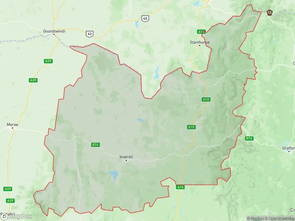
Inverell Tenterfield Introduction
Inverell Tenterfield is a town in the New England region of New South Wales, Australia. It is situated in the Macleay Valley and is the administrative center of the Inverell Shire. The town is known for its rich agricultural heritage, with cotton being a major crop grown in the area. The town has a population of around 10,000 people and is located approximately 450 kilometers northwest of Sydney. It is surrounded by picturesque countryside and has a number of historic buildings and landmarks, including the Inverell Courthouse and the Inverell Pioneer Cottage. The town also has a number of recreational facilities, including a golf course, a swimming pool, and a sports ground.Australia State
City or Big Region
District or Regional Area
Inverell Tenterfield Region Map
Inverell Tenterfield Postcodes / Zip Codes
Inverell Tenterfield Suburbs
Inverell Tenterfield full address
Inverell Tenterfield, New England and North West, New South Wales, NSW, Australia, SaCode: 11002Country
Inverell Tenterfield, New England and North West, New South Wales, NSW, Australia, SaCode: 11002
Inverell Tenterfield Suburbs & Region, Inverell Tenterfield Map & Postcodes has 6 areas or regions above, and there are 218 Inverell Tenterfield suburbs below. The sa3code for the Inverell Tenterfield region is 11002. Its latitude and longitude coordinates are -29.9162,152.229.
Inverell Tenterfield Suburbs & Localities
1. Boorolong
2. Camerons Creek
3. Auburn Vale
4. Gilgai
5. Inverell
6. Little Plain
7. Paradise
8. Swanbrook
9. Woodstock
10. Bald Blair
11. Bassendean
12. Brockley
13. Brushy Creek
14. Falconer
15. Georges Creek
16. Glen Nevis
17. Glencoe
18. Guyra
19. New Valley
20. Oban
21. The Basin
22. Tubbamurra
23. Diehard
24. Gibraltar Range
25. Glen Elgin
26. Moggs Swamp
27. Morven
28. Pinkett
29. Rangers Valley
30. Reddestone
31. Spring Mountain
32. Stonehenge
33. Yarrowford
34. Stannum
35. Wellington Vale
36. Yellow Dam
37. Delungra
38. Whitlow
39. Bukkulla
40. Graman
41. Newstead
42. Oakwood
43. Wandera
44. Ashford
45. Ben Lomond
46. Black Mountain
47. Maybole
48. South Guyra
49. The Gulf
50. Wandsworth
51. Brodies Plains
52. Cherry Tree Hill
53. Gum Flat
54. Kings Plains
55. Mount Russell
56. Rob Roy
57. Sapphire
58. Tingha
59. Bald Nob
60. Moogem
61. Newton Boyd
62. Tent Hill
63. The Gulf
64. Keera
65. Twin Rivers
66. Spring Mountain
67. Stanborough
68. Atholwood
69. Limestone
70. Pindaroi
71. Backwater
72. Baldersleigh
73. Briarbrook
74. Stannifer
75. Glen Innes
76. Kingsgate
77. Kingsland
78. Kookabookra
79. Lambs Valley
80. Red Range
81. Wellingrove
82. Deepwater
83. Tungsten
84. Coolatai
85. Warialda Rail
86. Gragin
87. Koloona
88. Bangheet
89. Bingara
90. Dinoga
91. Elcombe
92. Bakers Creek
93. Bundarra
94. Copeton
95. Elsmore
96. Howell
97. Long Plain
98. Nullamanna
99. Wallangra
100. Bonshaw
101. Green Hills
102. Llangothlin
103. Mount Mitchell
104. Tenterden
105. Old Mill
106. Dundee
107. Furracabad
108. Matheson
109. Shannon Vale
110. Swan Vale
111. Capoompeta
112. Emmaville
113. Rocky Creek
114. Torrington
115. Warialda
116. Balfours Peak
117. Myall Creek
118. Gineroi
119. Pallal
120. Upper Bingara
121. Yetman
122. Banyabba
123. Barcoongere
124. Baryulgil
125. Brushgrove
126. Buccarumbi
127. Barretts Creek
128. Blaxlands Creek
129. Blaxlands Flat
130. Bom Bom
131. Bookram
132. Alumy Creek
133. Braunstone
134. Calamia
135. Chaelundi
136. Clifden
137. Coutts Crossing
138. Crowther Island
139. Deep Creek
140. Elland
141. Fine Flower
142. Fortis Creek
143. Gurranang
144. Heifer Station
145. Junction Hill
146. Kangaroo Creek
147. Kyarran
148. Lanitza
149. Lilydale
150. Lower Coldstream
151. Lower Southgate
152. Mountain View
153. Rushforth
154. Sandy Crossing
155. South Grafton
156. The Whiteman
157. Waterview Heights
158. Winegrove
159. Carrs Island
160. Cowper
161. Dalmorton
162. Dilkoon
163. Dumbudgery
164. Eatonsville
165. Grafton
166. Lawrence
167. Malabugilmah
168. Mcphersons Crossing
169. Moleville Creek
170. Newbold
171. Seelands
172. Shannondale
173. Southampton
174. Tyndale
175. Upper Copmanhurst
176. Washpool
177. Whiteman Creek
178. Carrs Creek
179. Clarenza
180. Coombadjha
181. Copmanhurst
182. Grafton West
183. Keybarbin
184. Levenstrath
185. Lionsville
186. Nymboida
187. Southgate
188. Towallum
189. Trenayr
190. Waterview
191. Wombat Creek
192. Cangai
193. Carnham
194. Carrs Peninsula
195. Carrs Peninsular
196. Chambigne
197. Coaldale
198. Collum Collum
199. Dirty Creek
200. Eighteen Mile
201. Glenugie
202. Great Marlow
203. Halfway Creek
204. Jackadgery
205. Koolkhan
206. Kremnos
207. Kungala
208. Mylneford
209. Pulganbar
210. Punchbowl
211. Ramornie
212. Smiths Creek
213. South Arm
214. Stockyard Creek
215. The Pinnacles
216. Upper Fine Flower
217. Warragai Creek
218. Wells Crossing