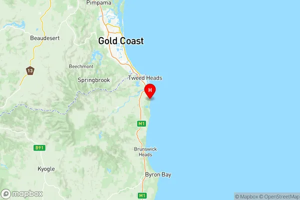
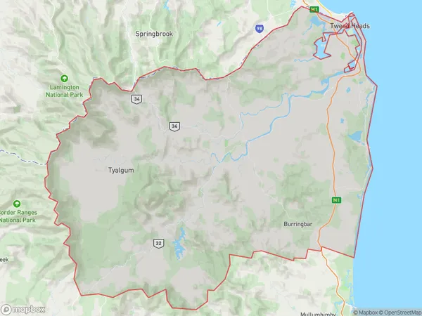
Tweed Valley Suburbs & Region, Tweed Valley Map & Postcodes
Tweed Valley Suburbs & Region, Tweed Valley Map & Postcodes in Tweed Valley, Richmond Tweed, NSW, AU
Tweed Valley Region
Region Name
Tweed Valley (NSW, AU)Tweed Valley Area
1308 square kilometers (1,308 ㎢)Postal Codes
2474, 2483, and from 2486 to 2490 (In total, there are 7 postcodes in Tweed Valley.)Tweed Valley Introduction
Tweed Valley is a region in the Northern Rivers district of New South Wales, Australia. It is located between the Border Ranges National Park and the Tweed River. The valley is known for its scenic beauty, including lush forests, waterfalls, and rivers. It is also a popular tourist destination, with many visitors coming to enjoy the outdoor activities, such as hiking, cycling, and fishing. The region is home to a number of small towns and villages, including Murwillumbah, Tweed Heads, and Coolangatta. The Tweed Valley is also a major producer of cotton, sugar cane, and bananas.Australia State
City or Big Region
District or Regional Area
Tweed Valley Region Map

Tweed Valley Postcodes / Zip Codes
Tweed Valley Suburbs
Brunswick Heads Ocean Shores
Kingscliff Fingal Head
Murwillumbah Region
Terranora North Tumblegum
Tweed Heads South
Tweed Valley full address
Tweed Valley, Richmond Tweed, New South Wales, NSW, Australia, SaCode: 11203Country
Tweed Valley, Richmond Tweed, New South Wales, NSW, Australia, SaCode: 11203
Tweed Valley Suburbs & Region, Tweed Valley Map & Postcodes has 9 areas or regions above, and there are 90 Tweed Valley suburbs below. The sa3code for the Tweed Valley region is 11203. Its latitude and longitude coordinates are -28.2887,153.574.
Tweed Valley Suburbs & Localities
1. Barkers Vale
2. Cedar Point
3. Collins Creek
4. Green Pigeon
5. Homeleigh
6. Kilgra
7. Little Back Creek
8. New Park
9. Roseberry
10. Sherwood
11. Wadeville
12. Warrazambil Creek
13. Wiangaree
14. Wyneden
15. Burringbar
16. Sleepy Hollow
17. Border Ranges
18. Cougal
19. Dairy Flat
20. Ettrick
21. Fawcetts Plain
22. Ghinni Ghi
23. Gradys Creek
24. Iron Pot Creek
25. Cobaki Lakes
26. Piggabeen
27. Casuarina
28. Kings Forest
29. Pottsville
30. North Tumbulgum
31. Loadstone
32. Terrace Creek
33. The Risk
34. Unumgar
35. West Wiangaree
36. Billinudgel
37. Ocean Shores
38. The Pocket
39. Bilambil
40. Bilambil Heights
41. Duroby
42. Terranora
43. Kingscliff
44. Bogangar
45. Pottsville Beach
46. Tumbulgum
47. Cawongla
48. Eden Creek
49. Edenville
50. Findon Creek
51. Grevillia
52. Horse Station Creek
53. Horseshoe Creek
54. Kyogle
55. Lynchs Creek
56. Old Grevillia
57. Rukenvale
58. Sawpit Creek
59. Smiths Creek
60. Toonumbar
61. Upper Horseshoe Creek
62. Mooball
63. Wooyung
64. Afterlee
65. Carool
66. Cobaki
67. Upper Duroby
68. Chinderah
69. Duranbah
70. Stotts Creek
71. Hastings Point
72. Geneva
73. Roseberry Creek
74. Upper Eden Creek
75. Brunswick Heads
76. Crabbes Creek
77. Middle Pocket
78. New Brighton
79. South Golden Beach
80. Upper Burringbar
81. Yelgun
82. Banora Point
83. Bungalora
84. Glengarrie
85. Tweed Heads South
86. Tweed Heads South Dc
87. Cudgen
88. Fingal Head
89. Cabarita Beach
90. Tanglewood
