Grafton Region Suburbs & Region, Grafton Region Map & Postcodes
Grafton Region Suburbs & Region, Grafton Region Map & Postcodes in Grafton Region, Richmond Valley Hinterland, Richmond Tweed, NSW, AU
Grafton Region Region
Region Name
Grafton Region (NSW, AU)Grafton Region Area
8446 square kilometers (8,446 ㎢)Postal Codes
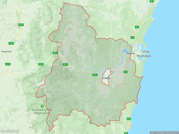
2370, 2450, 2460, 2462, 2463, 2469, and 2470 (In total, there are 7 postcodes in Grafton Region.)Grafton Region Suburb Area Map (Polygon)
Grafton Region Introduction
The Grafton Region is a local government area in the Northern Rivers region of New South Wales, Australia. It is located in the Clarence Valley and Mid-North Coast districts and includes the towns of Grafton, Maclean, Yamba, and Clarence Valley. The region has a population of approximately 35,000 people and covers an area of 1,119 square kilometers. The Grafton Region is known for its beautiful natural scenery, including the Clarence River, the Maclean River, and the Yamba River. It is also home to a number of important historical sites, including the Grafton Historic Town and the Yamba River National Park. The region is governed by the Grafton Regional Council, which has seven members elected every four years.Australia State
City or Big Region
Greater Capital City
Rest of NSW (1RNSW)District or Regional Area
Suburb Name
Grafton Region Region Map
Grafton Region Postcodes / Zip Codes
Grafton Region Suburbs
Grafton Region full address
Grafton Region, Richmond Valley Hinterland, Richmond Tweed, New South Wales, NSW, Australia, SaCode: 104011081Country
Grafton Region, Richmond Valley Hinterland, Richmond Tweed, New South Wales, NSW, Australia, SaCode: 104011081
Grafton Region Suburbs & Region, Grafton Region Map & Postcodes has 0 areas or regions above, and there are 115 Grafton Region suburbs below. The sa2code for the Grafton Region region is 104011081. Its latitude and longitude coordinates are -29.2196,152.603. Grafton Region area belongs to Australia's greater capital city Rest of NSW.
Grafton Region Suburbs & Localities
1. Newton Boyd
2. Glenreagh
3. Banyabba
4. Barcoongere
5. Baryulgil
6. Brushgrove
7. Buccarumbi
8. Sherwood
9. Barretts Creek
10. Blaxlands Creek
11. Blaxlands Flat
12. Bom Bom
13. Bookram
14. Braunstone
15. Calamia
16. Chaelundi
17. Clifden
18. Coutts Crossing
19. Deep Creek
20. Elland
21. Fine Flower
22. Fortis Creek
23. Gurranang
24. Heifer Station
25. Kangaroo Creek
26. Kyarran
27. Lanitza
28. Lilydale
29. Lower Coldstream
30. Lower Southgate
31. Mountain View
32. Rushforth
33. Sandy Crossing
34. The Whiteman
35. Waterview Heights
36. Winegrove
37. Calliope
38. Minnie Water
39. Pillar Valley
40. Swan Creek
41. Wooli
42. Ashby Heights
43. Ashby Island
44. Coongbar
45. Ewingar
46. Cowper
47. Dalmorton
48. Dilkoon
49. Dumbudgery
50. Eatonsville
51. Lawrence
52. Malabugilmah
53. Mcphersons Crossing
54. Moleville Creek
55. Newbold
56. Seelands
57. Shannondale
58. Tyndale
59. Upper Copmanhurst
60. Washpool
61. Whiteman Creek
62. Ulmarra
63. Ashby
64. Sandon
65. Woodford Island
66. Banyabba
67. Keybarbin
68. Louisa Creek
69. Clarenza
70. Coombadjha
71. Copmanhurst
72. Keybarbin
73. Levenstrath
74. Lionsville
75. Nymboida
76. Southgate
77. Towallum
78. Wombat Creek
79. Coldstream
80. Diggers Camp
81. Lavadia
82. Tucabia
83. Ilarwill
84. Tullymorgan
85. Woodford
86. Alice
87. Bulldog
88. Mookima Wybra
89. Alice
90. Cangai
91. Carnham
92. Chambigne
93. Coaldale
94. Collum Collum
95. Eighteen Mile
96. Glenugie
97. Halfway Creek
98. Jackadgery
99. Kremnos
100. Kungala
101. Mylneford
102. Pulganbar
103. Punchbowl
104. Ramornie
105. Smiths Creek
106. South Arm
107. Stockyard Creek
108. The Pinnacles
109. Upper Fine Flower
110. Warragai Creek
111. Wells Crossing
112. Gilletts Ridge
113. Lake Hiawatha
114. Shark Creek
115. Pikapene