Gympie Region Suburbs & Region, Gympie Region Map & Postcodes
Gympie Region Suburbs & Region, Gympie Region Map & Postcodes in Gympie Region, Maryborough, Wide Bay, QLD, AU
Gympie Region Region
Region Name
Gympie Region (QLD, AU)Gympie Region Area
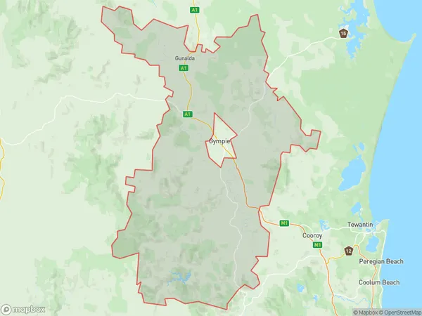
2545 square kilometers (2,545 ㎢)Gympie Region Suburb Area Map (Polygon)
Gympie Region Introduction
The Gympie Region is a regional area in Queensland, Australia, with a population of around 200,000 people. It is located in the Wide Bay-Burnett region and includes the cities of Gympie, Bundaberg, Maryborough, and Hervey Bay. The region is known for its natural beauty, including the Great Barrier Reef, Mount Superbus, and the Kolan River. It is also a major agricultural area, with crops such as sugarcane, cotton, and bananas being grown. The Gympie Region has a rich history and is home to several historic buildings and sites, including the Gympie Courthouse and the Gympie Gold Mining Museum.Australia State
City or Big Region
Greater Capital City
Rest of Qld (3RQLD)District or Regional Area
Suburb Name
Gympie Region Region Map
Gympie Region Suburbs
Gympie Region full address
Gympie Region, Maryborough, Wide Bay, Queensland, QLD, Australia, SaCode: 319031514Country
Gympie Region, Maryborough, Wide Bay, Queensland, QLD, Australia, SaCode: 319031514
Gympie Region Suburbs & Region, Gympie Region Map & Postcodes has 0 areas or regions above, and there are 0 Gympie Region suburbs below. The sa2code for the Gympie Region region is 319031514. Its latitude and longitude coordinates are -26.5,152.7. Gympie Region area belongs to Australia's greater capital city Rest of Qld.