Castlemaine Region Suburbs & Region, Castlemaine Region Map & Postcodes
Castlemaine Region Suburbs & Region, Castlemaine Region Map & Postcodes in Castlemaine Region, Loddon Elmore, Bendigo, VIC, AU
Castlemaine Region Region
Region Name
Castlemaine Region (VIC, AU)Castlemaine Region Area
1515 square kilometers (1,515 ㎢)Postal Codes
3364, 3444, from 3446 to 3448, 3451, 3453, and from 3461 to 3463 (In total, there are 10 postcodes in Castlemaine Region.)Castlemaine Region Suburb Area Map (Polygon)
Castlemaine Region Introduction
The Castlemaine Region is a local government area in central Victoria, Australia. It covers an area of approximately 1,100 square kilometers and is located about 100 kilometers north-west of Melbourne. The region is home to the towns of Castlemaine, Maldon, and Daylesford, as well as a number of smaller communities and rural areas. The Castlemaine Region is known for its rich cultural heritage, including the famous Castlemaine State Festival, which attracts thousands of visitors each year. The region is also home to a number of historic buildings and landmarks, including the Gold Mine Museum, the Castlemaine Gaol, and the Old Mill. The region is a major producer of food and beverages, including wine, cheese, and chocolate. It is also home to a number of industries, including manufacturing, agriculture, and tourism. The Castlemaine Region is a beautiful and diverse area with something to offer everyone. Whether you are interested in history, culture, or nature, there is something for you in this region.Australia State
City or Big Region
Greater Capital City
Rest of Vic. (2RVIC)District or Regional Area
Suburb Name
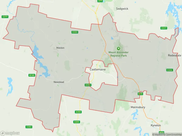
Castlemaine Region Region Map
Castlemaine Region Postcodes / Zip Codes
Castlemaine Region Suburbs
Castlemaine Region full address
Castlemaine Region, Loddon Elmore, Bendigo, Victoria, VIC, Australia, SaCode: 202021028Country
Castlemaine Region, Loddon Elmore, Bendigo, Victoria, VIC, Australia, SaCode: 202021028
Castlemaine Region Suburbs & Region, Castlemaine Region Map & Postcodes has 0 areas or regions above, and there are 46 Castlemaine Region suburbs below. The sa2code for the Castlemaine Region region is 202021028. Its latitude and longitude coordinates are -37,144.25. Castlemaine Region area belongs to Australia's greater capital city Rest of Vic..
Castlemaine Region Suburbs & Localities
1. Strathlea
2. Joyces Creek
3. Metcalfe East
4. Redesdale
5. Drummond North
6. Elphinstone
7. Metcalfe
8. Gower
9. Guildford
10. Irishtown
11. Tarilta
12. Yapeen
13. Barfold
14. Newstead
15. Baringhup West
16. Neereman
17. Perkins Reef
18. Porcupine Flat
19. Sutton Grange
20. Fryerstown
21. Woodbrook
22. Harcourt North
23. Yandoit Hills
24. Green Gully
25. Sandon
26. Bradford
27. Maldon
28. Nuggetty
29. Taradale
30. Vaughan
31. Joyces Creek
32. Baringhup
33. Eastville
34. Gower
35. Tarrengower
36. Langley
37. Barkers Creek
38. Faraday
39. Glenluce
40. Muckleford
41. Harcourt
42. Ravenswood South
43. Strangways
44. Muckleford South
45. Welshmans Reef
46. Walmer