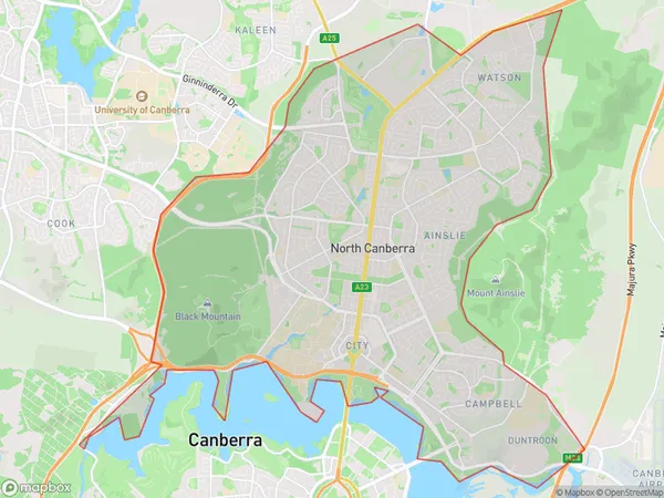
North Canberra Suburbs & Region, North Canberra Map & Postcodes
North Canberra Suburbs & Region, North Canberra Map & Postcodes in North Canberra, Australian Capital Territory, ACT, AU
North Canberra Region
Region Name
North Canberra (ACT, AU)North Canberra Area
44.72 square kilometers (44.72 ㎢)Postal Codes
2602, 2612, 2616, 2617, and 2912 (In total, there are 5 postcodes in North Canberra.)North Canberra Introduction
North Canberra is a suburb of Canberra, Australian Capital Territory, Australia. It is located in the northern part of the city and is bordered by the Molonglo River to the east, the Gungahlin Drive to the south, and the Barton Highway to the west. North Canberra is known for its leafy streets, well-maintained parks, and a variety of residential properties. It is home to several government agencies, including the Australian Bureau of Statistics and the Australian Taxation Office. The suburb also has a vibrant community with a variety of shops, restaurants, and cafes. North Canberra is a popular destination for families and professionals looking for a quiet and convenient lifestyle.Australia State
City or Big Region
District or Regional Area
North Canberra Region Map

North Canberra Postcodes / Zip Codes
North Canberra Suburbs
Parkes (ACT) North
North Canberra full address
North Canberra, Australian Capital Territory, ACT, Australia, SaCode: 80105Country
North Canberra, Australian Capital Territory, ACT, Australia, SaCode: 80105
North Canberra Suburbs & Region, North Canberra Map & Postcodes has 22 areas or regions above, and there are 23 North Canberra suburbs below. The sa3code for the North Canberra region is 80105. Its latitude and longitude coordinates are -35.2628,149.144.
North Canberra Suburbs & Localities
1. Oconnor
2. Braddon
3. Reid
4. Belconnen
5. Lawson
6. University Of Canberra
7. Dickson
8. Campbell
9. Belconnen Dc
10. Ainslie
11. Downer
12. Hackett
13. Lyneham
14. Watson
15. Belconnen
16. Bruce
17. Mckellar
18. Oconnor
19. Turner
20. Evatt
21. Giralang
22. Kaleen
23. Gungahlin
