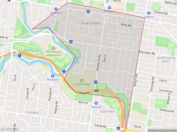
Hawthorn South Suburbs & Region, Hawthorn South Map & Postcodes
Hawthorn South Suburbs & Region, Hawthorn South Map & Postcodes in Hawthorn South, Boroondara, Melbourne Inner East, VIC, AU
Hawthorn South Region
Region Name
Hawthorn South (VIC, AU)Hawthorn South Area
3.22 square kilometers (3.22 ㎢)Hawthorn South Introduction
Hawthorn South is a suburb in Melbourne, Australia, 6 km east of Melbourne's central business district (CBD). It is represented by the Legislative Assembly of Victoria as the electoral district of Hawthorn. At the 2016 census, Hawthorn South had a population of 11,496. The suburb is named after the hawthorn tree, which is common in the area. Hawthorn South is located in the City of Boroondara local government area. The suburb has a variety of shops, restaurants, and cafes, as well as several parks and recreational facilities. It is also home to the Hawthorn Football Club, which plays in the Australian Football League (AFL). The club has a strong following and has won several premierships. Hawthorn South is well-connected to the rest of Melbourne, with several bus and train lines passing through the area. It is also close to several major roads, including the Monash Freeway and the EastLink freeway.Australia State
City or Big Region
Greater Capital City
Greater Melbourne (2GMEL)District or Regional Area
Suburb Name
Hawthorn South Suburbs
Hawthorn South full address
Hawthorn South, Boroondara, Melbourne Inner East, Victoria, VIC, Australia, SaCode: 207011520Country
Hawthorn South, Boroondara, Melbourne Inner East, Victoria, VIC, Australia, SaCode: 207011520
Hawthorn South Suburbs & Region, Hawthorn South Map & Postcodes has 0 areas or regions above, and there are 0 Hawthorn South suburbs below. The sa2code for the Hawthorn South region is 207011520. Hawthorn South area belongs to Australia's greater capital city Greater Melbourne.
