Merredin Suburbs & Region, Merredin Map & Postcodes
Merredin Suburbs & Region, Merredin Map & Postcodes in Merredin, Wheat Belt North, Western Australia Wheat Belt, WA, AU
Merredin Region
Region Name
Merredin (WA, AU)Merredin Area
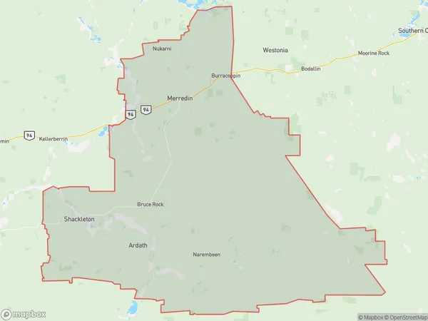
9828 square kilometers (9,828 ㎢)Merredin Suburb Area Map (Polygon)
Merredin Introduction
Merredin is a town in the Wheatbelt region of Western Australia, 235 km east of Perth, the state capital. It is the administrative center of the Merredin Shire. The town was established in 1891 and named after the Merredin railway station. The town is a major agricultural hub, with a large wheat industry. The town has a population of around 4,000 people and is known for its historic architecture and vibrant community. The Merredin Visitor Center is a popular tourist attraction, showcasing the region's history and culture. The town also has a hospital, a primary school, a secondary school, a supermarket, a post office, and several cafes and restaurants. The nearby Merredin Pool is a popular swimming spot during the summer months.Australia State
City or Big Region
Greater Capital City
Rest of WA (5RWAU)District or Regional Area
Suburb Name
Merredin Region Map
Merredin Suburbs
Merredin full address
Merredin, Wheat Belt North, Western Australia Wheat Belt, Western Australia, WA, Australia, SaCode: 509021240Country
Merredin, Wheat Belt North, Western Australia Wheat Belt, Western Australia, WA, Australia, SaCode: 509021240
Merredin Suburbs & Region, Merredin Map & Postcodes has 0 areas or regions above, and there are 0 Merredin suburbs below. The sa2code for the Merredin region is 509021240. Its latitude and longitude coordinates are -32.0653,118.396. Merredin area belongs to Australia's greater capital city Rest of WA.