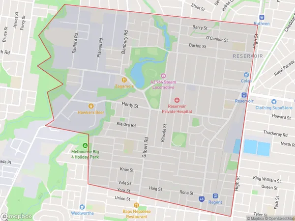
Reservoir South West Suburbs & Region, Reservoir South West Map & Postcodes
Reservoir South West Suburbs & Region, Reservoir South West Map & Postcodes in Reservoir South West, Darebin North, Melbourne North East, VIC, AU
Reservoir South West Region
Region Name
Reservoir South West (VIC, AU)Reservoir South West Area
5.62 square kilometers (5.62 ㎢)Reservoir South West Introduction
Reservoir South West is a suburb of Melbourne, Victoria, Australia 8 km north-east of Melbourne's central business district. Its local government area is the City of Whittlesea. At the 2016 Census, Reservoir South West had a population of 11,736. The suburb is named after the Reservoir railway station, which was located on the North East line. The station was opened in 1889 and closed in 1969. The suburb is mostly residential, with a mix of single-family homes, apartments, and townhouses. There are several parks and recreational facilities in the suburb, including the Reservoir Reserve, which has a playground, cricket pitch, and basketball court. The suburb is also home to several shopping centers, including the Reservoir Village Shopping Centre and the North East Shopping Centre.Australia State
City or Big Region
Greater Capital City
Greater Melbourne (2GMEL)District or Regional Area
Suburb Name
Reservoir South West Suburbs
Reservoir South West full address
Reservoir South West, Darebin North, Melbourne North East, Victoria, VIC, Australia, SaCode: 209021526Country
Reservoir South West, Darebin North, Melbourne North East, Victoria, VIC, Australia, SaCode: 209021526
Reservoir South West Suburbs & Region, Reservoir South West Map & Postcodes has 0 areas or regions above, and there are 0 Reservoir South West suburbs below. The sa2code for the Reservoir South West region is 209021526. Reservoir South West area belongs to Australia's greater capital city Greater Melbourne.
