Emu Plains Leonay Suburbs & Region, Emu Plains Leonay Map & Postcodes
Emu Plains Leonay Suburbs & Region, Emu Plains Leonay Map & Postcodes in Emu Plains Leonay, Penrith, Sydney Outer West and Blue Mountains, NSW, AU
Emu Plains Leonay Region
Region Name
Emu Plains Leonay (NSW, AU)Emu Plains Leonay Area
13.79 square kilometers (13.79 ㎢)Postal Codes
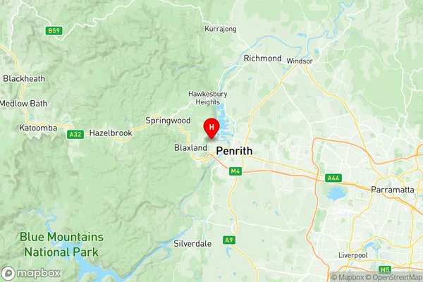
2750 (In total, there are 1 postcodes in Emu Plains Leonay.)Emu Plains Leonay Suburb Area Map (Polygon)

Emu Plains Leonay Introduction
Emu Plains is a suburb of Sydney, located in the state of New South Wales, Australia. It is situated in the local government area of the City of Canada Bay and is part of the Greater Western Sydney region. Emu Plains is approximately 26 kilometers west of the Sydney central business district and is bordered by the suburbs of Lidcombe, North Ryde, and Macquarie Fields. The suburb has a rich history and was originally inhabited by the Darug people, who were the traditional owners of the land. The area was first settled by Europeans in the 18th century, and the name "Emu Plains" comes from the emus that were once found in the area. The suburb has a variety of housing options, including apartments, townhouses, and detached homes. Emu Plains is well-connected to the rest of Sydney, with several bus routes and train stations nearby. The suburb also has a number of parks and recreational facilities, including the Emu Plains Reserve, which is a popular spot for picnics and outdoor activities. The area is known for its peaceful and quiet atmosphere, making it an ideal place for families and professionals looking for a suburban lifestyle.Australia State
City or Big Region
Greater Capital City
Greater Sydney (1GSYD)District or Regional Area
Suburb Name
Emu Plains Leonay Region Map
Emu Plains Leonay Postcodes / Zip Codes
Emu Plains Leonay Suburbs
Emu Plains Leonay full address
Emu Plains Leonay, Penrith, Sydney Outer West and Blue Mountains, New South Wales, NSW, Australia, SaCode: 124031459Country
Emu Plains Leonay, Penrith, Sydney Outer West and Blue Mountains, New South Wales, NSW, Australia, SaCode: 124031459
Emu Plains Leonay Suburbs & Region, Emu Plains Leonay Map & Postcodes has 0 areas or regions above, and there are 3 Emu Plains Leonay suburbs below. The sa2code for the Emu Plains Leonay region is 124031459. Its latitude and longitude coordinates are -33.7352,150.65. Emu Plains Leonay area belongs to Australia's greater capital city Greater Sydney.
Emu Plains Leonay Suburbs & Localities
1. Emu Plains
2. Leonay
3. Emu Heights