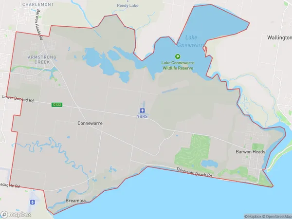
Barwon Heads Armstrong Creek Suburbs & Region, Barwon Heads Armstrong Creek Map & Postcodes
Barwon Heads Armstrong Creek Suburbs & Region, Barwon Heads Armstrong Creek Map & Postcodes in Barwon Heads Armstrong Creek, Surf Coast Bellarine Peninsula, Geelong, VIC, AU
Barwon Heads Armstrong Creek Region
Region Name
Barwon Heads Armstrong Creek (VIC, AU)Barwon Heads Armstrong Creek Area
88.21 square kilometers (88.21 ㎢)Barwon Heads Armstrong Creek Introduction
Barwon Heads Armstrong Creek is a locality in the City of Greater Geelong, Victoria, Australia. It is located on the Bellarine Peninsula, approximately 45 kilometers south-west of Geelong's central business district and 25 kilometers north-west of the regional city of Torquay. The area is known for its scenic coastline, with several beaches and parks. It is also home to a number of wineries and golf courses. Barwon Heads Armstrong Creek has a population of approximately 4,000 people and is a popular tourist destination.Australia State
City or Big Region
Greater Capital City
Rest of Vic. (2RVIC)District or Regional Area
Suburb Name
Barwon Heads Armstrong Creek Suburbs
Barwon Heads Armstrong Creek full address
Barwon Heads Armstrong Creek, Surf Coast Bellarine Peninsula, Geelong, Victoria, VIC, Australia, SaCode: 203031489Country
Barwon Heads Armstrong Creek, Surf Coast Bellarine Peninsula, Geelong, Victoria, VIC, Australia, SaCode: 203031489
Barwon Heads Armstrong Creek Suburbs & Region, Barwon Heads Armstrong Creek Map & Postcodes has 0 areas or regions above, and there are 0 Barwon Heads Armstrong Creek suburbs below. The sa2code for the Barwon Heads Armstrong Creek region is 203031489. Barwon Heads Armstrong Creek area belongs to Australia's greater capital city Rest of Vic..
