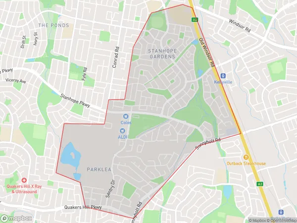
Stanhope Gardens Parklea Suburbs & Region, Stanhope Gardens Parklea Map & Postcodes
Stanhope Gardens Parklea Suburbs & Region, Stanhope Gardens Parklea Map & Postcodes in Stanhope Gardens Parklea, Blacktown North, Sydney Blacktown, NSW, AU
Stanhope Gardens Parklea Region
Region Name
Stanhope Gardens Parklea (NSW, AU)Stanhope Gardens Parklea Area
3.9 square kilometers (3.9 ㎢)Stanhope Gardens Parklea Introduction
Stanhope Gardens is a public housing estate located in Parklea, Sydney, New South Wales, Australia. It is situated in the Blacktown local government area and is known for its large size and diverse population. The estate was developed in the 1960s and 1970s and consists of a mix of high-rise apartments and townhouses. It is home to many families and individuals from a variety of cultural backgrounds, including Indigenous Australians, Asians, and Africans. Stanhope Gardens is known for its poor living conditions and high crime rates, but there are also many community organizations and initiatives working to improve the estate and its residents' lives. The estate has a community center, a library, a health clinic, and a number of parks and recreational facilities. It is also home to a number of small businesses and shops.Australia State
City or Big Region
Greater Capital City
Greater Sydney (1GSYD)District or Regional Area
Suburb Name
Stanhope Gardens Parklea Suburbs
Stanhope Gardens Parklea full address
Stanhope Gardens Parklea, Blacktown North, Sydney Blacktown, New South Wales, NSW, Australia, SaCode: 116021633Country
Stanhope Gardens Parklea, Blacktown North, Sydney Blacktown, New South Wales, NSW, Australia, SaCode: 116021633
Stanhope Gardens Parklea Suburbs & Region, Stanhope Gardens Parklea Map & Postcodes has 0 areas or regions above, and there are 0 Stanhope Gardens Parklea suburbs below. The sa2code for the Stanhope Gardens Parklea region is 116021633. Stanhope Gardens Parklea area belongs to Australia's greater capital city Greater Sydney.
